Context and feedback to date
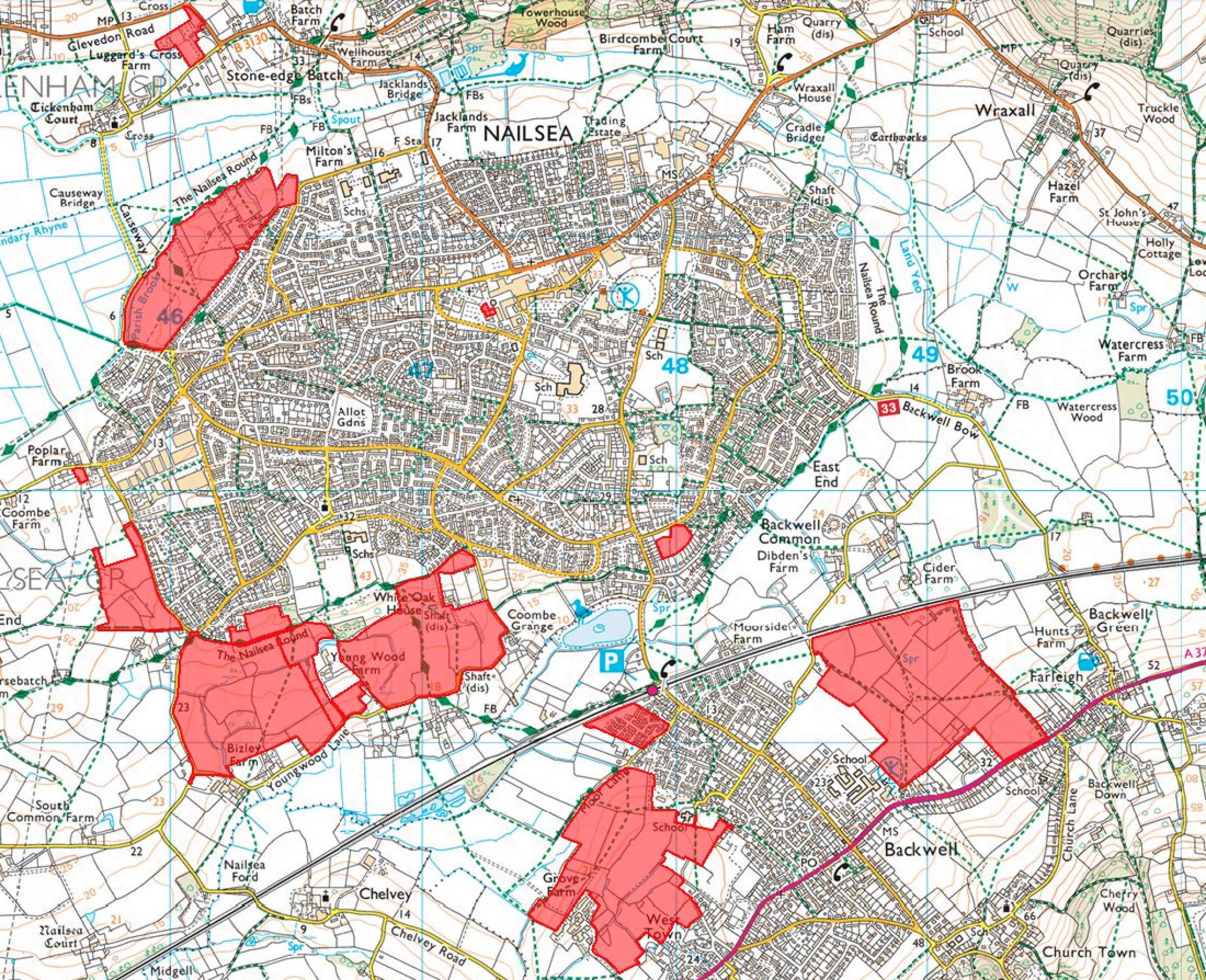
Land at ‘North-West Nailsea’ was allocated for mixed-use development including up to 450 homes and 1.5ha employment space in North Somerset’s 2026 Local Plan. Vistry controls the central and southern parts of the allocated site, other landowners control the land to the north.
The plans have been delayed by National Grid's work grounding the pylons on the site. Since then, a detailed set of technical and environmental assessments have been undertaken to understand the site’s opportunities and constraints to development.
A landscape-led approach has been taken to masterplanning, which has produced a masterplan with more than 50% green infrastructure and the provision of almost 4 times the policy requirement for open space.
There has been a large amount of feedback on the site allocation over the years, a summary of which is included below. If you have further feedback, please do get in touch.
North Somerset Local Plan 2038 broad locations - Click image to enlarge
| Feedback | Our response |
| Should deliver a mix of family, starter and downsizing homes to help counter Nailsea’s ageing population. | The proposals will allow for a range of house types and sizes, helping to meet the needs of all the community. |
| Needs to make a positive contribution to the built environment and sense of place being safe and attractive. | The application proposals have been carefully designed to reflect local character and to create a vibrant new community that is attractive and safe for residents. The illustrative masterplan has been landscape-led in its design, creating an environment that can be enjoyed by existing and future residents of Nailsea. |
| Should enhance public open space. | The proposed development provides a significant amount of public open space enhancement, greater than required by local policy, which greatly benefits the character of the local area. |
| Should champion biodiversity, protecting and enhancing existing trees and hedgerows. | The illustrative masterplan has been influenced by its setting and has retained all important trees and hedgerows alongside new planting. The development is committed to delivering more than 10% biodiversity net gain. |
| Should champion climate change | The homes will meet Future Homes Standard, and be gas free. Further details will be included in the Reserved Matters application. |
| Should support and encourage walking, cycling and improved public transport, and help minimise congestion | The proposed development supports all active form of travel into the design. New walking and cycle routes have been provided within the site and PROW retained. The development will also benefit from its proximity to bus stops on Queens Road to help encourage sustainable forms of transport and minimise congestion. |
| Should consider neighbours | The proposed illustrative masterplan ensures that the amenity of neighbouring properties is protected. Vistry will work with the Council to ensure any disruption is kept to a minimum during future construction. |
| Concerns around vehicle access | The proposed access is via Waterly Lane. The scheme is also helping deliver the new spine road, which is designed to take pressure of the local roads. |
| Major improvements are needed on the Clevedon Road through Tickenham | The wider highway network is being looked at by North Somerset. Any S106 contributions towards off-site highway improvement works deemed necessary will be agreed with the Council and paid by Vistry. |
| A minimum 20 metre strip protecting the landscape along the Causeway where it abuts would be a real improvement. | The development has ensured that landscape and ecological areas of importance have been at the forefront of the design process. The appropriate buffers have been included where required across the site. |
Opportunities and constraints
One of the first stages of bringing forward a site for development is to better understand the site and pull together an opportunities and constraints plan. This encompasses a wide range of studies including ground conditions, utilities and flood risk constraints, ecology, landscape, heritage and archaeology, drainage, access and highways, the local context including existing neighbours, planning policy and many other influences.
Key opportunities include new open space, improved ecology and the spine road, as shown on the plan to the right.

Opportunities and constraints - Click image to enlarge
Developing the concept masterplan
Based on the constraints and opportunities, we’ve developed the below illustrative masterplan, showing how the site could come forward and we’d be interested to hear your views.
We’d stress that this is an Outline application, it does not include detail of the design of the homes, precise locations, the parking and other detailed matters. A Reserved Matters application will follow next year (subject to planning) looking at this.

Concept masterplan - Click image to enlarge
Landscape
The proposals include 5.6 hectares (54% of the site) of high value, multi-functional green space for the surrounding community and wildlife to enjoy. It includes new meadow and wetland areas, orchards and allotments, space for recreation, play and walking, and extensive tree and hedgerow planting, all aiming to enhance the quality of the place and benefit biodiversity and wellbeing.
More than 156 varieties of apple are recorded as having a connection with Somerset, however, more than 50% of Somerset’s orchards have been lost in the last 50 years. Orchards can provide local food growing opportunities in urban areas, exciting amenity spaces, as well as providing habitats for species over time as the orchards age.

Landscape plan - Click image to enlarge
Local facilities
The following shows the proximity of the site to local facilities such as bus stops, schools, doctors and the town centre. Most are within a 20-minute walk with good existing bus, cycle and pedestrian links.
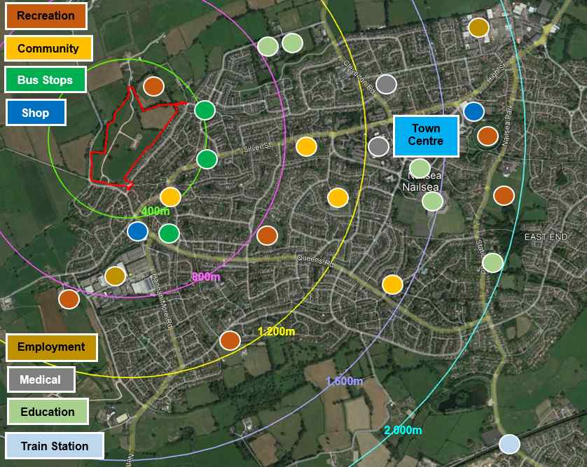
Local facilities - Click image to enlarge
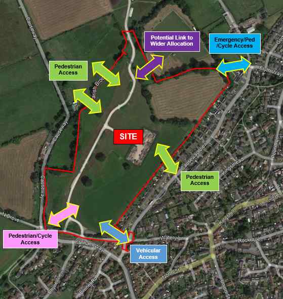
Routes and movement
Movement priorities have been around access, encouraging active and sustainable travel, encouraging people to leave their cars at home and improving connections to public rights of way.
The most notable change is a new road into the site through Watery Lane, providing access for vehicles, pedestrians and cyclists. This proposed route would take priority over Causeway View, which will become the minor arm of a new three-arm priority junction and help take traffic off Causeway View.
Pedestrian access is proposed from five broad locations as follows:
- Via the vehicular access on Watery Lane in the south-east
- To/from Watery Lane in the south-west
- To/from the existing public right of way to the north-west
- To/from the existing public right of way onto Causeway View
- To/from Fryth Way in the north-east
Cycle access is proposed from three broad locations as follows:
- Via the vehicular access on Watery Lane (using the carriageway) in the south-east
- To/from Watery Lane in the south-west
- To/from Fryth Way in the north-east
An emergency access is proposed from Fryth Way that will also provide access for pedestrians and cyclists.
Local facilities - Click image to enlarge